Zeming, Liu, as Innovation Hub Manager at PARIFEX, which technical innovation do you want to share with our readers?
I am going to talk about the Vehicle Identification System. At first sight, it seems impossible to know which vehicle has gone too fast while looking at a 2D picture including various vehicles. This system allows to accurately identify the speeding vehicle through two principles: the vehicle recognition and the capability to cut it out on the picture.
How does it work precisely?
Firstly, as the picture will be in two dimensions, perspective must be defined with the sensor. Through our research, we have found robust image processing solutions in order to determine the leak point on the road and then easily identify the lanes despite difficulties like 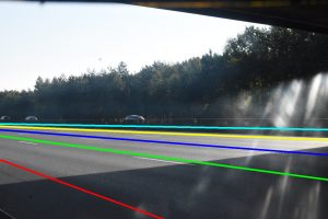 shadows which could distort the information (picture on left). Through our mathematical studies and research in geometric equations, we are able to correct the perspective on the road and draw the lanes without any additional on-site measures. When the sensor starts, it is automatically configured depending on the location.
Can you guarantee that the identified vehicle is the defective one?
Our research has enabled to correct perspective and prove which is the defective vehicle. On a picture showing an offense, the information in two dimensions is not deformed by the perspective through a mathematical algorithm found by PARIFEX which creates a linearity with the distance in three dimensions measured by the LiDAR sensor. On the image, the vehicle has two information in terms of distance: a distance in three dimensions and another one defined by our picture analyzing algorithm.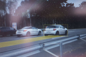 Given their linear relationship (picture on right), the 3D distance allows to determine on which line is the vehicle. When we know the 3D position of the vehicle, then we can easily identify the lane.
Is there an impact on the use of the sensor?
The automatic calibration of the sensor is easier and does not need any intervention of a surveyor, for example. The user only needs to put the sensor by the roadside and wait for around thirty vehicles passing by in order to have the sensor ready to use.